


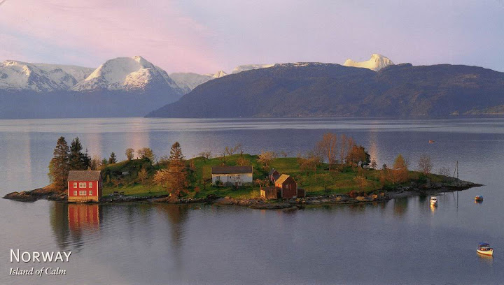
Island of Calm, Oma, Hardangerfjord, Norway

With a length of 179 km (111 miles), the Hardangerfjord in the county of Hordaland in Norway is the third largest fjord in the world and the second largest in Norway. The surrounding district is called Hardanger.
The Hardangerfjord starts at the Atlantic Ocean just south of Bergen (SW Norway). Here the fjord penetrates in a north easterly direction until it meets the grand mountain plateau of Hardangervidda. The longest branch of the Hardangerfjord is Sørfjorden which cuts south about 50 km from the main fjord. Its maximum depth is more than 800 m (2,624 ft) just outside Norheimsund in the middle of the fjord.
About 10,000 years ago the Scandinavian land mass started to rise up as enormous glacial ice started to melt. The lower parts of the valleys became flooded, and so created what we today know as the Hardangerfjord. The valley was originally not only made through glacial erosion but by the high pressure melting water which pushed its way beneath the ice.
Today the Hardangerfjord is witness to a renaissance in tourism and new infrastructure for travellers has once again become an industry for the local communities along the fjord.
哈當厄峽灣(Hardangerfjorden)位於挪威霍達蘭郡,長達179公里,是世界上第三長峽灣,也是挪威第二長峽灣。其周邊區域為哈當厄。
哈當厄峽灣始於大西洋畔,卑爾根的南面。峽灣沿著東北方向蜿蜒,直到哈當厄高原。哈當厄峽灣最長的分支為南峽灣,從主峽灣往南,長達50公里。峽灣最深處超過800米,位於峽灣中部諾海姆桑德。
大約1萬年前,斯堪的納維亞大陸開始向上抬升,大量的冰川開始融化。山谷的低處被水淹沒,形成了今天的哈當厄峽灣。山谷的形成不僅僅由於冰川侵蝕,還與冰下面高壓力的融化水的推動相關。
目前,該峽灣被劃分成13個自治市,總計人口7萬,面積8471平方公里。
References sources : Wikipedia


 Postcards received from


1 comments:
Fantastic place, this is my dream island :-)
Post a Comment