|
| Windmills of Zaanse Schans, Netherland |


Skin Design: Jasmine85
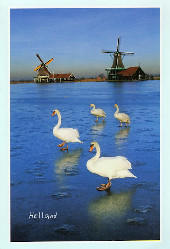

Zaanse Schans is a neighbourhood of Zaandam, near Zaandijk in the municipality of Zaanstad in the Netherlands, in the province of North Holland. It has a collection of well-preserved historic windmills and houses. Zaanse Schans is one of the popular tourist attractions of the region and an Anchor Point of ERIH, The European Route of Industrial Heritage. The neighbourhood is a popular tourist location with approximately 900,000 visitors every year.
The windmills were built after 1574.
贊斯安斯(Zaanse Schans),是荷蘭西北的北荷蘭省贊代克市附近的一個小村。贊斯安斯有「荷蘭風車博物館」之稱,收羅保存完好的荷蘭古式風車和房屋,荷蘭一個著名的旅遊景點。
References sources : wikipedia


Majorca (Spanish and Catalan: Mallorca) is the largest island of Spain. It is located in the Mediterranean Sea and part of the Balearic Islands archipelago. The name derives from Latin insula maior, "larger island"; later Maiorica.
The capital of the island, Palma, is also the capital of the autonomous community of the Balearic Islands. The Cabrera archipelago is administratively grouped with Majorca (in the municipality of Palma). The anthem of Majorca is La Balanguera.
Like the other Balearic Islands of Ibiza, Formentera, and Minorca, the island is a popular tourist destination. In Germany, the United Kingdom and to a lesser extent, Ireland, where package tourism to the island started in May 1952, Majorca has remained a popular destination.
馬略卡(西班牙語:Mallorca)是西班牙的巴利阿里群島的最大島嶼,是著名的旅遊點和觀鳥去處。 中世紀以瓷器著名(意大利花飾瓷器),多古羅馬、腓尼基和迦太基遺址。其首府帕爾馬同時是整個自治區的首府。
References sources : wikipedia
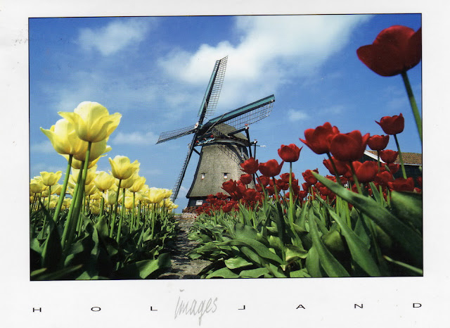


The Netherlands is so closely associated with windmills, that it's often the first fact people recall about the country. The Dutch built windmills for many centuries (and to some extent, the windmills built the country itself, since without them much of the land drainage could not have occured). In that time the mills were developed for corn milling, land drainage, saw milling, and in fact all manner of industrial purposes. Despite this widespread use, Dutch mills are in may ways quite primitive - using canvas sails, and turned to wind by hand (as distinct from the automated mechanisms that were developed for English windmills, including the fantail, and shuttered sails).
There are a very pleasing number of remaining windmills in the Netherlands - the number is about 1150 and rising, in that the Dutch only count complete workable mills, and in the past 10 years especially many extensive rebuilds have occured to add to this number.
荷兰素有“风车王国”的美称,在荷兰随处可见的一座座古朴而典雅优美的风车,给这个美丽的国度增添了几分姿色。1229年荷兰人发明了世界上第一座风车,从此开始了人类使用风车的历史。风车首先在荷兰出现主要取决于荷兰独特的地理位置和荷兰人对动力的迫切需求。荷兰这一国名在英语和荷兰语中都是“低洼之地”的意思,荷兰是世界著名的低洼之国,国内3/5的土地低于海平面,余下的 2/5海拔不到1米。
荷兰地处欧洲西部海岸,与大不列颠岛遥遥相望并构成漏斗形尾部的地理特征,大西洋季风从北海长驱直入,荷兰正处风带要冲,长年受益,风车也就应运而生。到了18世纪,荷兰风车达到了鼎盛时期,全国有18000座风车,风车除了用来排水灌溉外,还用来磨米发电,荷兰人依靠这些风车变沧海为良田,建设美好家园。一代又一代的荷兰人,修筑了坚固的海堤和沟渠,他们采用了风车逐级提水的方法,把倒灌的海水排入大海。然后通过种植不同种类的植物,把大片的盐碱地逐步改造成了茂盛的草场和鲜花的种植园。如今的荷兰,已经成为世界上最大的鲜花输出国,人均奶牛拥有量居世界第四,奶酪生产名冠全球。今天荷兰的大风车,已经成为了荷兰人精神的象征。它默默地矗立着,向每一个来到那里的人,无言地诉说着前人们艰苦创业和建设美好家园的动人故事。
19世纪后,荷兰风车开始走下坡路,风车的用途逐渐被蒸汽机和电力所取代。目前,荷兰仅剩970座风车,其中只有210座还在继续使用,余下的均作为历史古迹保留下来供人参观。荷兰人对风车有着深厚的感情,他们视风车为国家的“功臣”和国宝,把风车看成民族和国家的象征。每年5月的第二个星期六是荷兰的风车节,这一天全国的风车一齐转动举国欢庆。
References sources : windmillworld, 互动百科


Faial Island, also known in English as Fayal, is a Portuguese island of the Central group (Grupo Central) of the Azores. Its area is 173 km² and it is located 28.7° W longitude and 38.6° N latitude. The nearest island is Pico Island to the east. The island is also referred to as Ilha Azul (the "Blue Island"), by poet Raul Brandão, due to the large quantity of Hydrangeas that bloom during the summer months.
亚速尔群岛(葡萄牙语:Açores)是一位于北大西洋中央的群岛,为葡萄牙领土。面积共2,247平方公里。群岛由九个主要岛屿组成,包括圣米格尔、圣玛丽亚、法亚尔、皮库、圣若热、特塞拉、格拉西奥萨、弗洛里斯和科尔武。岛上地势崎岖、海岸陡峭,有许多火山锥、火口湖和热泉等。法亚尔岛是亚速尔群岛中最年轻的火山岛屿之一,长约20公里,由一座单一的玄武岩层火山形成。
References sources : wikipedia
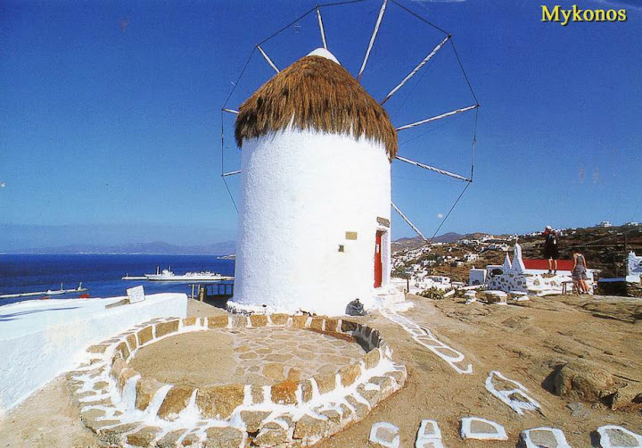


Mykonos is a Greek island and a tourist destination, renowned for its cosmopolitan character and its intense nightlife. The island is part of the Cyclades, lying between Tinos, Syros, Paros and Naxos. It spans an area of 105.183 km2 (41 sq mi) and rises at an elevation of 341 m (1,119 ft) at its highest point. The island is composed primarily of granite. It has little natural fresh water and relies on the desalination of sea water in order to meet its needs. There are 9,320 inhabitants (2001) most of whom live in the largest town, Mykonos, also known as Chora (i.e. the Town in Greek, a common denomination in Greece when the name of the island itself is the same as the name of the principal town), which lies on the west coast.
It is believed that the island was named after a local hero, who is considered an offspring of the god Apollo and was worshipped locally in antiquity.
米科諾斯(又译作密克诺斯)是希腊爱琴海上的一个小岛,因旅游业而闻名,是基克拉泽斯群岛之一。米科諾斯岛面积86平方公里,常住居民约6,200 (2002年)。全岛主要由花岗岩构成,最高点海拔364米。岛上的淡水供应主要来自海水淡化。
米克诺斯岛(Mykonos) 属希腊基克拉迪群岛的一个岛屿。位于提诺斯(Tinos) ,思罗斯(Siros) ,帕罗斯和纳克索斯诸岛之间。它涵盖的领域约有一百零五平方公里( 41平方英里) ,最高海拔有341米(一千一百一十九英尺)。这座岛屿,主要由花岗岩组成。全岛有9320人( 2001年),人口大多数生活在位于西海岸最大城市米科诺斯。据认为,该岛是以当地的一位英雄的名字命名,他被认为是阿波罗神的后代,自古以来一直受到当地人的崇拜。五十年代迎来第一批游客,是因为去考察附近的得罗斯岛上非凡的古代遗迹,路过此地。而今她以自己的大都市特征,迷人热烈的夜生活,阳光充足的沙滩,赢得了众多游客,成为大受欢迎的旅游胜地。
近几十年来,随着交通的便利,米科诺斯岛逐渐成为了旅游者的天堂。小岛美丽而宁静的风光吸引了众多来自世界各地的游客。在夏天,经常可以见到希腊和外国名人在岛上洁白的石径漫步或路边餐馆小酌。现在小岛已经成为了希腊乃至全世界最受欢迎的度假胜地之一。旅游业带动了当地房地产的发展,各种旅馆和度假屋遍布市区,以至于人们开始担心小岛会慢慢失去她本来的特色。庆幸的是,当地法律规定岛上每座房子都要定期粉刷并保持基克拉泽斯的建筑风格。
References sources : wikipedia


The Azores is a Portuguese archipelago in the Atlantic Ocean, about 1,500 km (930 mi) from Lisbon and about 3,900 km (2,400 mi) from the east coast of North America. The Monchique Islet on Flores Island, located at 31° 16' 24" W is regarded as the westernmost point in Europe, even though from a geographical standpoint, the two westernmost Azorean islands (Flores and Corvo) actually lie on the North American plate. The current Azores' main industries are tourism, cattle raising for milk and meat, and fishing.
The nine major Azorean islands and the eight small Formigas extend for more than 600 km (373 mi) and lie in a northwest-southeast direction. The vast extent of the islands defines an immense exclusive economic zone of 1,100,000 km2 (420,000 sq mi). The westernmost point of this area is 3,380 km (2,100 mi) from the North American continent. All of the islands have volcanic origins, although Santa Maria also has some reef contribution. The mountain of Pico on Pico Island, at 2,351 m (7,713 ft) in altitude, is the highest in all of Portugal. The Azores are actually the tops of some of the tallest mountains on the planet, as measured from their base at the bottom of the ocean. The archipelago forms the Autonomous Region of Azores, one of the two autonomous regions of Portugal.
Because these once uninhabited, remote islands were settled sporadically over a span of two centuries, their culture, dialect, cuisine and traditions vary considerably from island to island. Farming and fishing are key industries that support the Azorean economy. 240,000 Azoreans live within the archipelago’s 868 square miles.
亚速尔群岛(葡萄牙语:Açores)是一位于北大西洋中央的群岛,为葡萄牙领土。面积共2,247平方公里。群岛由九个主要岛屿组成,包括圣米格尔、圣玛丽亚、法亚尔、皮库、圣若热、特塞拉、格拉西奥萨、弗洛里斯和科尔武。首府为蓬塔德尔加达(位于圣米格尔岛上)。群岛西距欧洲大陆约1,600公里。一般认为亚速尔群岛在1427年由葡萄牙国王的领航员塞尼尔(D. de Senill)发现,当时岛上并无人类曾到此或居住的痕迹。约1432年开始建立居民点,到15世纪末,所有岛屿均有人居住,并与葡萄牙建立了良好的贸易关系。1580年至1640年间,亚速尔群岛曾隶属西班牙,1591年曾是英国与西班牙和葡萄牙两个半岛强国之间海战的战场。1766年葡萄牙任命一名管辖整个群岛的总督兼提督;1895年被给予有限的行政自治权。第二次世界大战时重要的空军和海军基地在此建立,1951年美国在拉日什设立北大西洋公约组织的空军基地。
皮库的产酒区于2004年被列入世界文化遗产。
References sources : Wikipedia


Zaanse Schans is a neighbourhood of Zaandam, near Zaandijk in the municipality of Zaanstad in the Netherlands, in the province of North Holland. It has a collection of well-preserved historic windmills and houses. Zaanse Schans is one of the popular tourist attractions of the region and an Anchor Point of ERIH, The European Route of Industrial Heritage. Approximately 900 000 visitors in every year.
The windmills were built after 1574.
贊斯安斯(Zaanse Schans),是荷蘭西北的北荷蘭省贊代克市附近的一個小村。贊斯安斯有「荷蘭風車博物館」之稱,收羅保存完好的荷蘭古式風車和房屋,荷蘭一個著名的旅遊景點。
References sources : Wikipedia
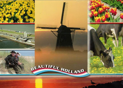


The Netherlands is so closely associated with windmills, that it's often the first fact people recall about the country. The Dutch built windmills for many centuries (and to some extent, the windmills built the country itself, since without them much of the land drainage could not have occured). In that time the mills were developed for corn milling, land drainage, saw milling, and in fact all manner of industrial purposes. Despite this widespread use, Dutch mills are in may ways quite primitive - using canvas sails, and turned to wind by hand (as distinct from the automated mechanisms that were developed for English windmills, including the fantail, and shuttered sails).
There are a very pleasing number of remaining windmills in the Netherlands - the number is about 1150 and rising, in that the Dutch only count complete workable mills, and in the past 10 years especially many extensive rebuilds have occured to add to this number.
荷兰素有“风车王国”的美称,在荷兰随处可见的一座座古朴而典雅优美的风车,给这个美丽的国度增添了几分姿色。1229年荷兰人发明了世界上第一座风车,从此开始了人类使用风车的历史。风车首先在荷兰出现主要取决于荷兰独特的地理位置和荷兰人对动力的迫切需求。荷兰这一国名在英语和荷兰语中都是“低洼之地”的意思,荷兰是世界著名的低洼之国,国内3/5的土地低于海平面,余下的 2/5海拔不到1米。
荷兰地处欧洲西部海岸,与大不列颠岛遥遥相望并构成漏斗形尾部的地理特征,大西洋季风从北海长驱直入,荷兰正处风带要冲,长年受益,风车也就应运而生。到了18世纪,荷兰风车达到了鼎盛时期,全国有18000座风车,风车除了用来排水灌溉外,还用来磨米发电,荷兰人依靠这些风车变沧海为良田,建设美好家园。一代又一代的荷兰人,修筑了坚固的海堤和沟渠,他们采用了风车逐级提水的方法,把倒灌的海水排入大海。然后通过种植不同种类的植物,把大片的盐碱地逐步改造成了茂盛的草场和鲜花的种植园。如今的荷兰,已经成为世界上最大的鲜花输出国,人均奶牛拥有量居世界第四,奶酪生产名冠全球。今天荷兰的大风车,已经成为了荷兰人精神的象征。它默默地矗立着,向每一个来到那里的人,无言地诉说着前人们艰苦创业和建设美好家园的动人故事。
19世纪后,荷兰风车开始走下坡路,风车的用途逐渐被蒸汽机和电力所取代。目前,荷兰仅剩970座风车,其中只有210座还在继续使用,余下的均作为历史古迹保留下来供人参观。荷兰人对风车有着深厚的感情,他们视风车为国家的“功臣”和国宝,把风车看成民族和国家的象征。每年5月的第二个星期六是荷兰的风车节,这一天全国的风车一齐转动举国欢庆。
References sources : windmillworld, 互动百科
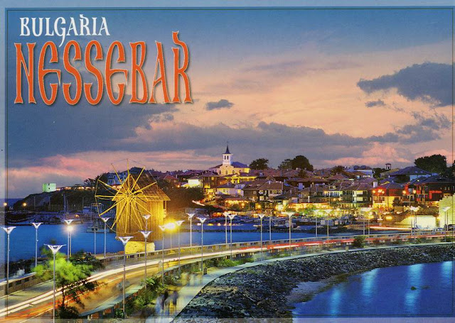


Nesebar is an ancient city and a major seaside resort on the Black Sea coast of Bulgaria, located in Nesebar municipality, Burgas Province. Often referred to as the "Pearl of the Black Sea" and "Bulgaria's Dubrovnik", Nesebar is a rich city-museum defined by more than three millennia of ever-changing history.
It is a one of the most prominent tourist destinations and seaports on the Black Sea, in what has become a popular area with several large resorts—the largest, Sunny Beach, is situated immediately to the north of Nesebar.
Nesebar has on several occasions found itself on the frontier of a threatened empire, and as such it is a town with a rich history. The ancient part of the town is situated on a peninsula (previously an island) connected to the mainland by a narrow man-made isthmus, and it bears evidence of occupation by a variety of different civilisations over the course of its existence. Its abundance of historic buildings prompted UNESCO to include Nesebar in its list of World Heritage Sites in 1983.
内塞巴尔古城建立于公元前两千年,历史上起防御功能。内塞巴尔(从前的是色雷人的梅森布利亚,后来为希腊人控制)位于保加利亚沿黑海的海岸一个半岛上的石质海角上。1934年以前,曾沿用其色雷斯名而称之为“梅森布里亚”。全城位于一个半岛上,与大陆仅有一线土地相联,半岛上多岩石,四周景色秀丽。沿着唯一的一条宽仅15-23米的通道,穿过围墙中的古门,方能进入。建城已有2000余年的历史。
色雷人从公元前十二世纪到公元前六世纪居住于梅内布里亚,这里是黑海上最古老的人类定居点。梅森布利亚在公元前510年左右成为希腊的殖民地,是当时本都-尤辛努斯地区(Pontus-Euxinus),即现在的黑海地区殖民地中最古老的一个。公元72年,梅森布利亚被罗马帝国的势力征服。公元395,随着罗马帝国的分裂,这里成为拜占庭帝国的重要据点。拜占庭期,曾为富饶的商业城市。保加利亚的第一个王国在公元812年到927年处于国家全盛时期。在接下来的几个世纪里,这座城市交替处于希腊和保加利亚的统治之下。梅森布利亚即后来的密斯维里(Misivri)在公元1453年成为奥斯曼帝国的附庸,也正在那一年君士坦丁堡被攻陷。之后,这里一直到1878年都处于土耳其的统治之下。
内塞巴尔现为一处疗养胜地,有著名的“向阳海滩”。城内多历史古迹,这里留存的10多座教堂几乎代表了基督教文明的每一个时期,从建于公元五世纪的最古老教堂直到上世纪末的教堂,每代都有杰出建筑,故有“天然博物馆之称”,其中大部分建于十三、十四世纪,以圣约翰.阿利特格托斯教堂最为精致,保存也较好,施洗者圣约翰教堂也很吸引人,这些教堂的建筑工艺富有独创性。小块的凝灰岩和数排砖头交错重叠,构成不同寻常的装饰图案。在自然的防御站点的入口发现的公元前6世纪的希腊防御工事的遗迹,塔楼以石灰石包装,遗迹大小为800m×300m,其中拥有小广场和窄小的、弯曲的街道。
城市的木质建筑装饰以彩色的石头和陶瓷,可追溯到18、19世纪保加利亚文艺复兴时期。中世纪拜占庭和保加利亚建成的包括内赛巴尔古建筑群在内的和谐的建筑群,包括教堂和礼拜堂,是和谐的砖石结构。“内赛巴尔是数个已经灭绝文明见证”,它“再现了从不同方面,一个濒危帝国边境的边塞城市的重要历史地位。”
内巴塞尔古城位于黑海多岩石的半岛上,3000年前遗址最初是色雷斯的殖民地。后来,这座城市成为希腊殖民地而且是拜占庭帝国最重要的要塞之一。城市的古迹大约可以从希腊化时代开始,古城包括卫城、阿波罗神庙和广场。其他重要的古迹是建于19世纪具有普罗夫迪夫风格的旧米特罗利亚大会堂和木屋。
内塞巴尔古城于1983年根据文化遗产遴选标准C(Ⅲ)(Ⅳ)被列入《世界遗产目录》。
References sources : wikipedia, 百度百科


Santorini is a small, circular archipelago of volcanic islands located in the southern Aegean Sea, about 200 km southeast from Greece's mainland. It is also known as Thera , forming the southernmost member of the Cyclades group of islands, with an area of approximately 73 km² (28 mi²) and a 2001 census population of 13,670. It is composed of the Municipality of Thíra (pop. 12,440) and the Community of Oía (Οία, pop. 1,230, which includes 268 inhabitants resident on the offshore island of Therasia, lying to the west). These have a total land area of 90.623 km², which also includes the uninhabited islands of Nea Kameni, Palaia Kameni, Aspronisi, and Christiana (all part of the Municipality of Thira).
Santorini is essentially what remains of an enormous volcanic explosion, destroying the earliest settlements on what was formerly a single island, and leading to the creation of the current geological caldera. Its spectacular physical beauty, along with a dynamic nightlife, have made the island one of Europe's tourist hotspots.
A giant central lagoon, more or less rectangular, and measuring about 12 km by 7 km (8 mi by 4 mi), is surrounded by 300 m (984 ft) high steep cliffs on three sides. The island slopes downward from the cliffs to the surrounding Aegean Sea. On the fourth side, the lagoon is separated from the sea by another much smaller island called Therasia; the lagoon merges with the sea in two places, in the northwest and southwest. The water in the centre of the lagoon is nearly 400 m (1300 ft) deep, thus making it a safe harbour for all kinds of shipping. The island's harbours all lie in the lagoon and there are no ports on the outer perimeter of the island; the capital, Fira, clings to the top of the cliff looking down on the lagoon. The volcanic rocks present from the prior eruptions feature olivine and have a notably small presence of hornblende.
It is the most active volcanic centre in the South Aegean Volcanic Arc, though what remains today is chiefly a water-filled caldera. The volcanic arc is approximately 500 km long and 20-40 km wide. The region first became volcanically active around 3-4 million years ago though volcanism on Thera began around 2 millin years ago with the extrusion of dacitic lavas from vents around the region of Akrotiri. The name Santorini was given to it by the Latin empire in the thirteenth century, and is a reference to Saint Irene. Before then it was known as Kallistē (Καλλίστη, "the most beautiful one"), Strongylē (Στρογγύλη, "the circular one"), or Thera.
The island is the site of one of the largest volcanic eruptions the planet has ever seen: the Minoan eruption (sometimes called the Thera eruption), which occurred some 3,600 years ago at the height of the Minoan civilization. The eruption left a large caldera surrounded by volcanic ash deposits hundreds of feet deep and may have led indirectly to the collapse of the Minoan civilization on the island of Crete, 110 km (70 miles) to the south, through the creation of a gigantic tsunami. Another popular theory holds that the Thera eruption is the source of the legend of Atlantis.
圣托里尼(希腊文:Σαντορίνη)是在希腊大陆东南200公里的爱琴海上由一群火山组成的岛环,位于北纬 36.40° —东经 25.40°。圣托里尼岛环上最大的一个岛也叫圣托里尼岛,别名锡拉岛(Θήρα)。圣托里尼岛位于基克拉泽斯群岛的最南端,面积约73平方公里,人口约一万四千余人,多为希腊人。“圣托里尼”是十三世纪时威尼斯人所命名的,起源于圣·爱莲(義大利語:Santa Irene);在此前这个岛称为锡拉岛、卡利斯提(Καλλίστη,在古希臘語意為“最美”)或斯特隆基里(Στρογγύλη)。
3500年前这里发生一次几千年来最猛烈的火山爆发,留下一个大火山口和几百米厚的火山灰,可能间接地促成克里特岛米诺斯文明的消亡。
References sources : wikipedia


Ios is an island in the Cyclades group in the Aegean Sea. It is a part of Greece. Ios is a hilly island with cliffs down to the sea on most sides, situated halfway between Naxos and Santorini. It is about 18km (11 mi) long and 10km (6 mi) wide, with an area of about 109 km² (42 mi²). Population was 1,838 in 2001 (down from 3,500 in the 19th century). Ios was the setting for the movie Ginger and Cinnamon (Dillo con parole mie). Also, scenes from the film Big Blue (Le Grand Bleu) were shot in Manganari.
伊奥斯岛享有“聚会之岛”之称,白天的日光浴和夜晚的酒是这个小岛独有的特色。
References sources : wikipedia


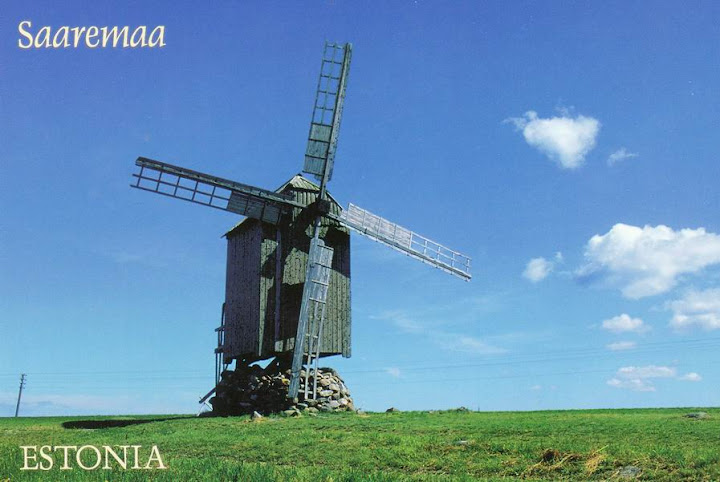


Saaremaa (German: Ösel, Swedish: Ösel) is the largest island belonging to Estonia, measuring 2,673 km². The main island of Saare County, it is located in the Baltic Sea, south of Hiiumaa island, and belongs to the West Estonian Archipelago (Moonsund archipelago). The capital of Saaremaa is Kuressaare, which has about 15,000 inhabitants; the whole island has over 39,000 inhabitants.
萨列马岛(爱沙尼亚语、英语:Saaremaa;芬兰语:Saarenmaa;瑞典语、德语:Ösel;拉丁语:Osilia),爱沙尼亚第一大岛,面积2673平方公里。萨列马岛位于波罗的海里加湾西口处,北隔索埃尔海峡与希乌马岛相邻,南隔伊尔别海峡与拉脱维亚相望。全岛属薩雷縣管辖,人口4万人,首府库雷萨雷,人口1.6万人。
References sources : wikipedia


The Netherlands is so closely associated with windmills, that it's often the first fact people recall about the country. The Dutch built windmills for many centuries (and to some extent, the windmills built the country itself, since without them much of the land drainage could not have occured). In that time the mills were developed for corn milling, land drainage, saw milling, and in fact all manner of industrial purposes. Despite this widespread use, Dutch mills are in may ways quite primitive - using canvas sails, and turned to wind by hand (as distinct from the automated mechanisms that were developed for English windmills, including the fantail, and shuttered sails).
There are a very pleasing number of remaining windmills in the Netherlands - the number is about 1150 and rising, in that the Dutch only count complete workable mills, and in the past 10 years especially many extensive rebuilds have occured to add to this number.
荷兰素有“风车王国”的美称,在荷兰随处可见的一座座古朴而典雅优美的风车,给这个美丽的国度增添了几分姿色。1229年荷兰人发明了世界上第一座风车,从此开始了人类使用风车的历史。风车首先在荷兰出现主要取决于荷兰独特的地理位置和荷兰人对动力的迫切需求。荷兰这一国名在英语和荷兰语中都是“低洼之地”的意思,荷兰是世界著名的低洼之国,国内3/5的土地低于海平面,余下的 2/5海拔不到1米。
荷兰地处欧洲西部海岸,与大不列颠岛遥遥相望并构成漏斗形尾部的地理特征,大西洋季风从北海长驱直入,荷兰正处风带要冲,长年受益,风车也就应运而生。到了18世纪,荷兰风车达到了鼎盛时期,全国有18000座风车,风车除了用来排水灌溉外,还用来磨米发电,荷兰人依靠这些风车变沧海为良田,建设美好家园。一代又一代的荷兰人,修筑了坚固的海堤和沟渠,他们采用了风车逐级提水的方法,把倒灌的海水排入大海。然后通过种植不同种类的植物,把大片的盐碱地逐步改造成了茂盛的草场和鲜花的种植园。如今的荷兰,已经成为世界上最大的鲜花输出国,人均奶牛拥有量居世界第四,奶酪生产名冠全球。今天荷兰的大风车,已经成为了荷兰人精神的象征。它默默地矗立着,向每一个来到那里的人,无言地诉说着前人们艰苦创业和建设美好家园的动人故事。
19世纪后,荷兰风车开始走下坡路,风车的用途逐渐被蒸汽机和电力所取代。目前,荷兰仅剩970座风车,其中只有210座还在继续使用,余下的均作为历史古迹保留下来供人参观。荷兰人对风车有着深厚的感情,他们视风车为国家的“功臣”和国宝,把风车看成民族和国家的象征。每年5月的第二个星期六是荷兰的风车节,这一天全国的风车一齐转动举国欢庆。
References sources : windmillworld, 互动百科
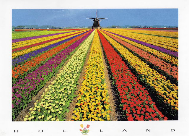


The Netherlands is so closely associated with windmills, that it's often the first fact people recall about the country. The Dutch built windmills for many centuries (and to some extent, the windmills built the country itself, since without them much of the land drainage could not have occured). In that time the mills were developed for corn milling, land drainage, saw milling, and in fact all manner of industrial purposes. Despite this widespread use, Dutch mills are in may ways quite primitive - using canvas sails, and turned to wind by hand (as distinct from the automated mechanisms that were developed for English windmills, including the fantail, and shuttered sails).
There are a very pleasing number of remaining windmills in the Netherlands - the number is about 1150 and rising, in that the Dutch only count complete workable mills, and in the past 10 years especially many extensive rebuilds have occured to add to this number.
荷兰素有“风车王国”的美称,在荷兰随处可见的一座座古朴而典雅优美的风车,给这个美丽的国度增添了几分姿色。1229年荷兰人发明了世界上第一座风车,从此开始了人类使用风车的历史。风车首先在荷兰出现主要取决于荷兰独特的地理位置和荷兰人对动力的迫切需求。荷兰这一国名在英语和荷兰语中都是“低洼之地”的意思,荷兰是世界著名的低洼之国,国内3/5的土地低于海平面,余下的 2/5海拔不到1米。
荷兰地处欧洲西部海岸,与大不列颠岛遥遥相望并构成漏斗形尾部的地理特征,大西洋季风从北海长驱直入,荷兰正处风带要冲,长年受益,风车也就应运而生。到了18世纪,荷兰风车达到了鼎盛时期,全国有18000座风车,风车除了用来排水灌溉外,还用来磨米发电,荷兰人依靠这些风车变沧海为良田,建设美好家园。一代又一代的荷兰人,修筑了坚固的海堤和沟渠,他们采用了风车逐级提水的方法,把倒灌的海水排入大海。然后通过种植不同种类的植物,把大片的盐碱地逐步改造成了茂盛的草场和鲜花的种植园。如今的荷兰,已经成为世界上最大的鲜花输出国,人均奶牛拥有量居世界第四,奶酪生产名冠全球。今天荷兰的大风车,已经成为了荷兰人精神的象征。它默默地矗立着,向每一个来到那里的人,无言地诉说着前人们艰苦创业和建设美好家园的动人故事。
19世纪后,荷兰风车开始走下坡路,风车的用途逐渐被蒸汽机和电力所取代。目前,荷兰仅剩970座风车,其中只有210座还在继续使用,余下的均作为历史古迹保留下来供人参观。荷兰人对风车有着深厚的感情,他们视风车为国家的“功臣”和国宝,把风车看成民族和国家的象征。每年5月的第二个星期六是荷兰的风车节,这一天全国的风车一齐转动举国欢庆。
References sources : windmillworld, 互动百科


 Postcards received from